Preview
Description
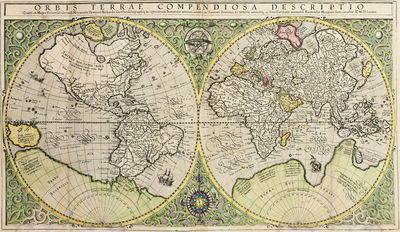
Published in 1587 in a printing of Geography by Strabo (circa 64 BCE – 24 CE), translated by Isaac Casaubon (1559-1614), this hand-colored copperplate engraving print is the work of Rumold Mercator (1545-1599), completed with the sources and personal guidance of his father, Gerhard Mercator (1512-1594).
This map also appeared in the Mercators' 1595 work Atlas Sive Cosmographicae Meditationes de Fabrica Mvndi et Fabricati Figvra, published in Duisburg.
Transcription
The title of this item is "Orbis Terrae Compendiosa Descriptio," which roughly translates to "A Compendious Description of Earth."
Below main title is printed: "Quam ex magna Vniversali Gerardi Mercatoris Domino Richardo Gartho, Geographie ac ceterarum bonarum artium amatori ac fautori summo, in veteris amicitie ac familiaritatis memoria Rumoldus Mercator fieri curabat. A.o M D. Lxxxvii." Rough translation: "From the great general of Gerard Mercator, Sir Richard Gartho, a lover of geography and other fine arts, and a consummate supporter of old friendship and familiarity, Rumold Mercator was anxious to be remembered. Year of 1587."
Creation Date
1587
City
Duisburg
State/Province
North Rhine - Westphalia
Country
Germany
Creator Life Dates
1545–1599
Keywords
map, "world map", Mercator, "Mercator projection", Strabo, "Strabo's Geography, " 1587, copperplate, "copperplate engraving", print, paper, color, hand-colored, Latin, "Orbis Terrae Compendiosa Descriptio", Renaissance, Casaubon, "Isaac Casaubon", "A Compendious Description of Earth", latitude, longitude, ocean, "sea monster", "sea monsters", land, Earth, mapping, navigation, cosmography, atlas, ships
Resource Identifier
Bound in [Spec Coll]PA4439 .E5 G4 1587
Date Digital
Fall 12-10-2021
Document Type
Image
Disciplines
Ancient, Medieval, Renaissance and Baroque Art and Architecture | Archival Science | Book and Paper | Cultural History | Digital Humanities | European History | Geography | Graphic Design | History of Science, Technology, and Medicine | Illustration | Industrial and Product Design | Medieval Studies | Political History | Printmaking | Race, Ethnicity and Post-Colonial Studies | Renaissance Studies
Publisher
Wofford College
Format (medium)
Maps
Format (IMT)
image/jpeg
Language
Medieval Latin
Digitization Specifications
This jpeg is a composite image made from two scans of the item at 600dpi. The scans were stitched together with Adobe Photoshop, and saved and compressed into a JPEG image file (66MB) whose resolution is also 600dpi.
Source
[Spec Coll] PA4439 .E5 G4 1587
Recommended Citation
Mercator, Rumold and Mercator, Gerhard, "Orbis Terrae Compendiosa Descriptio" (1587). Selections from Special Collections. 1.
https://digitalcommons.wofford.edu/selectspeccoll/1
Creative Commons License

This work is licensed under a Creative Commons Attribution 4.0 International License.
Keywords
map, "world map", Mercator, "Mercator projection", Strabo, "Strabo's Geography, " 1587, copperplate, "copperplate engraving", print, paper, color, hand-colored, Latin, "Orbis Terrae Compendiosa Descriptio", Renaissance, Casaubon, "Isaac Casaubon", "A Compendious Description of Earth", latitude, longitude, ocean, "sea monster", "sea monsters", land, Earth, mapping, navigation, cosmography, atlas, ships